
Walk a Buckhannon Street
A useful Buckhannon street directory search separates ownership, address geography, and dated evidence of occupancy. The state assessment system can return parcels for a street, but the owner shown is not automatically the person living there. The WV Property Viewer adds parcel shapes and E-911 labels. Deeds explain transfers, while voter records and old directories can add dated resident evidence. Each source answers a different question.
Start broad, then narrow. Street suffixes, compass directions, old spellings, and postal forms can split a single road across several searches. Record the exact label used by each office before deciding two results describe the same place.
- Select Upshur County in the assessment search, enter the street name without a house number, and compare the returned district, map, parcel, physical, and mailing labels.
- Open a candidate in the WV Property Viewer. Check its E-911 address, parcel shape, physical label, nearby parcels, and assessment-report link.
- Use a known name and date of birth in the state voter lookup, or ask the Upshur County Clerk about lawful inspection of precinct records. Do not treat a voter entry as a full household list.
- Carry the parcel and deed book/page to the county clerk. Trace the grantor and grantee index only after the legal description confirms the parcel.
- For an older address, check the dated city and telephone directory runs. Preserve the printed street form and publication year.
Buckhannon Assessment Street Search
The official West Virginia Property Assessment Search is the strongest first stop for a present-day street sweep. Choose Upshur County, add the Buckhannon district when known, and search the normalized street name. Searching without the house number first helps reveal all candidate parcels and catches numbering errors. Results can be expanded with legal-description and GIS parcel-ID columns or downloaded as CSV for working notes.
| Search area | Fields and controls | Street use |
|---|---|---|
| Basic parcel search | County, district, full parcel ID, owner, map, street, parcel, sub-parcel, property class, tax class, land use | Build the parcel list along a named road |
| Appraisal and sales | Land, building and total appraisal; acres; price; sale-from and sale-through dates | Narrow a large result set without claiming occupancy |
| Advanced search | Flood hazard, mailing address, deed book/page, legal description, building year, structures and area | Match a candidate to a deed or building description |
| Result tools | Matching count, query URL, legal-description and GIS-ID display, Property Viewer link, CSV results | Document and check each result |
The captured assessment search screen shows how many distinct controls sit behind a Buckhannon by-street query.
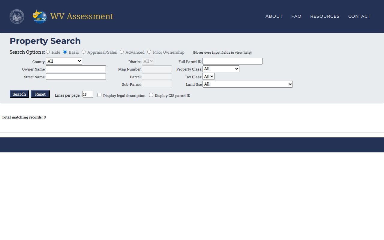
The screen is a search form, not proof of a resident. A blank field does not prove the fact is absent from the assessor's office or deed file.
Buckhannon Address Labels Compared
One parcel may carry several valid labels. Assessment mailing address means where a tax notice goes. The physical or situs address identifies the site for assessment purposes. E-911 addressing helps emergency response. USPS supplies a delivery form and ZIP. A deed may identify the land through lot, tract, subdivision, road, or metes-and-bounds language instead of a modern number. Keep those labels in separate columns rather than forcing them into one value.
- Parcel
- A tax-mapping unit identified by county, district, map, parcel, and sometimes sub-parcel values.
- Situs address
- The physical location assigned to the property, which may differ from the owner's mailing address.
- Plat
- A recorded drawing that describes lots, roads, and other mapped features. It is distinct from a web parcel overlay.
- Criss-cross directory
- A dated directory arranged by street or telephone number, useful for finding a listing at an address.
This distinction prevents a common error: naming a tax-bill recipient as a Buckhannon occupant. Compare the physical and E-911 fields, then seek an independent dated source if the question is who lived there.
Map Buckhannon Streets in GIS
The WV Property Viewer adds geographic context to an address search. It accepts an E-911 address, parcel attributes, coordinates, geometry, or a geometry buffer. Zoom until parcel polygons can be selected, then use Details and Highlight. Roads, imagery, topography, address numbers, and flood-zone layers help resolve which tract fronts the road.
The official viewer's Copy Link, Download KMZ, and export controls are useful for notes, yet they do not replace the assessor record or a recorded survey. The official Buckhannon District 05G tax-map sheet likewise warns that its lines were compiled from available records, were not field verified, and are not a survey. Use the map to find a parcel, not to settle a boundary.
Buckhannon Records Listed by Street
A complete street directory relies on all documented access channels. Some records are online, some require a courthouse or office request, and older series may be available only through archives or local collections. The parcel number and legal description are the best bridges between systems when a street spelling changes.
| Address record | Responsible source | What it can establish | How to reach it |
|---|---|---|---|
| Assessment search | WV Tax Department and Upshur Assessor | Owner or taxpayer display, map/parcel, address labels, deed and value fields | Online query; assessor follow-up in Room 102 at 38 W Main Street |
| Parcel map | WV Property Viewer | Parcel shapes, E-911 labels, physical fields, flood and adjacent-parcel context | Online map, report link, KMZ or CSV-style tools |
| Deed index | Upshur County Clerk and WV Archives | Transfer parties, book/page and prior-owner trail | Clerk counter, phone, mail, fax or email follow-up; older index and microfilm at Archives |
| Voter records | WV Secretary of State and county clerk | Individual registration result or lawful precinct-list fields | Name-and-birth-date lookup; clerk inspection or list request |
| City address files | City of Buckhannon | Zoning, flood, street, drainage, vacant-structure, hearing or decision records | Ordinance/minute archive; specific city FOIA request |
| Dated directories | WV Archives, library and UCHS | Listings tied to an address and publication year | Holdings list, reading room, local reference query or appointment |
No public, all-years Upshur deed-image portal was verified. Call the clerk before a long visit to confirm the current search method, counter hours, and copy charges.
Buckhannon Deeds Behind Addresses
The assessor can expose a deed book and page, but the Upshur County Clerk is the verified recording route. Take the map and parcel values, current deed reference, and legal description to Room 101 at 40 West Main Street. Search the named owner as grantee to locate the acquisition, then search the seller as grantee for the prior transfer. Confirm the same legal description at every step.
Grantor means the person or entity transferring an interest; grantee means the one receiving it. Trust deeds, releases, liens, judgments, tax sales, estate transfers, and plats may sit beside ordinary deeds. An index entry alone does not prove clear title or current occupancy. For earlier research, the WV Archives inventory lists Upshur deeds from 1815 through 1902 and deed indexes from 1815 through 1970, with a second deed series covering 1851 through 1901 and an index through 1970.
The WV Archives Upshur inventory is the finding aid for that older material. Later work continues through the clerk, whose official directory provides phone, fax, email, and postal contact routes.
Buckhannon Street Names Can Shift
Buckhannon documented a concrete addressing problem in its 2020 street-name survey. The city described concern that Leonard Street and Elizabeth Street could be confused during emergency response and sought names for a connector between West Main and Franklin. Apothecary Way, Coplin Way, Olive Way, Rusmisell Way, and Vandalia Way were proposed. The survey does not by itself prove which name was finally adopted.
Search later council minutes and ordinances before translating an old label into a current one. County agenda material also points to coordination among addressing staff, the communications center, the city, USPS, and the West Virginia Division of Highways. That material is a historical lead, so confirm today's procedure before making a formal request.
For ward or municipal context, consult the city charter's named-street boundaries. Then compare the charter, E-911 field, GIS label, USPS form, and directory spelling. This small case explains why a by-address search should preserve every version.
Buckhannon Street and Zoning Files
City records add dated actions that do not appear on a parcel card. Buckhannon's ordinance index covers streets and drainage, zoning, flood matters, vacant structures, and related municipal subjects. Council minutes and agendas include recent postings and can identify a hearing, application, or public project tied to a street or parcel. Keep the role of each named person, such as applicant, owner, representative, or speaker, rather than calling that person a resident.
No verified public citywide permit search was found. Start with the online ordinance and council archives. If the needed file is missing, send a specific request through the City of Buckhannon FOIA route. Ask for a date range, record type, exact street, and parcel or hearing date. City instructions allow email or recorder contact and do not require a special form. The stated ordinary-copy charge is 75 cents per page.
Buckhannon Voter Street Limits
The state voter lookup is built for one known person, not a public street browse. It requires first name, last name, and date of birth, then may report registration status, party, districts, and polling place from the most recent county record. It updates nightly. A polling result helps place a voter in election geography, but it does not identify every occupant of an address.
West Virginia law also permits examination of active, inactive, rejected, and canceled records at the county clerk, subject to office procedure. Precinct lists may include permitted name, residence address, party, and status fields, with a stated noncommercial fee of one cent per name. Phone numbers, email addresses, Social Security numbers, and driver identification numbers are excluded. Solicitation and resale are barred. Use the Upshur County Clerk for inspection and printed-list access rather than treating the Buckhannon street directory as an open voter dump.
Older Buckhannon Street Listings
A dated city or telephone directory can show who was listed at an address when the volume was issued. WV State Archives lists Buckhannon city directories from 1972 through 2016 with many gaps, plus telephone directories for 1962 and 1977 through 2005. A telephone volume can bridge some missing city-directory years, though it may include businesses, omit unlisted numbers, or use a different address convention.
The full holdings and how entries should be read belong on the Buckhannon city directory page. For street work, copy only what is printed: volume title, year, page or image, street form, listing name, and any role or household notation. “Listed at this address in 1995” is supportable. “Lived here for years” requires more records.
Buckhannon Street ZIP Checks
USPS verifies Buckhannon's postal ZIP as 26201, but a postal label is not the city boundary. A rural Upshur County parcel may use Buckhannon as its postal city, and a parcel inside municipal limits may not line up with a ward name. No official street-by-street ZIP and city-limit crosswalk was found.
Use the USPS address-to-ZIP mode for one delivery address. Use city-and-state or cities-by-ZIP searches only for postal relationships, not parcel ownership or occupancy. Preserve an old rural-route, box, or historic street form beside the standardized result. The assessment portal is searchable by street and district, not by a confirmed ZIP-wide control, and the Property Viewer is not postal authority.
Buckhannon Street Directory Limits
A property roll usually names an owner or taxpayer, not every person in a home. Renters and other household members may never appear in ownership records. A voter list is not a household roster. Utility customer and delivery records were not verified as public resident sources, while motor-vehicle address data is restricted. Sealed court material and protected vital records can also be unavailable.
The West Virginia Address Confidentiality Program gives eligible survivors a substitute address for mail and certain official uses. Never reverse-search or compare a suspected substitute address against parcel data. An apparent mismatch may reflect protection, normal mailing practice, stale data, or a simple same-name error.
Lawful use. Use Buckhannon address records for legitimate personal research, civic review, or family history. Never use them to stalk, harass, intimidate, or expose a protected person.
Official sources also have limits. GIS boundaries are not surveys, an index is not a certified instrument, and a search result may be incomplete. Cite the source date and ask the custodian to validate facts that matter.